
Why Ladakh Villages Sit Exactly Where the Glacier Stream Leaves the Rock
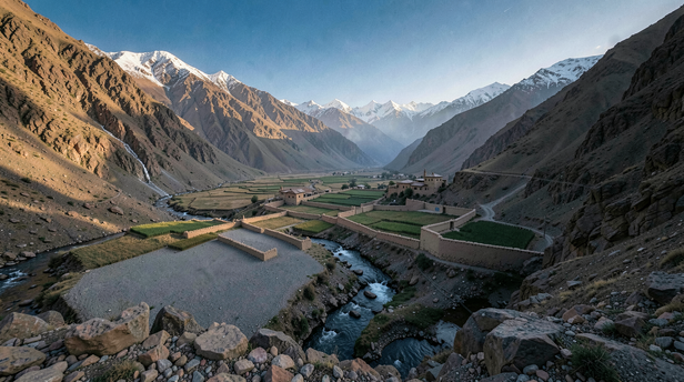
A traveller moving through Ladakh notices, after the third or fourth village, that the pattern is too regular to be coincidence. The valley floor is bare gravel and wind-scoured stone for kilometres at a stretch. Then the mountain wall breaks open at a side canyon, a thin silver thread of water comes down, and there, exactly at the point where the stream fans out across the flat, are the houses, the barley fields, the monastery on the shelf above.
Alchi sits on this logic as plainly as any settlement in the region. The Alchi stream descends from the glaciers above and deposits its load, silt, fine sand, mineral-rich debris, precisely where the gradient drops and the water loses the energy to carry it further. That deposit is the village's foundation in every sense: the soil that holds moisture, the ground that can be terraced, the place where a channel can be cut and water directed without a pump or an engine.
What a Glacier Stream Carries That a River Does Not
The streams that feed Ladakhi villages are not ordinary mountain water. They are meltwater, which means they travel through ice and over rock for months before reaching a settlement, picking up the ground-up mineral flour that glaciers produce as they grind across stone. This flour, sometimes called glacial milk for the pale colour it gives the water, is extraordinarily fine and extraordinarily fertile. Where it settles, it builds soil of a quality that the surrounding desert cannot match.
A river fed by rain carries whatever the catchment gives it, which in an arid high-altitude range is very little. A glacier-fed stream carries the mountain itself, in suspension, and deposits it in a thin but workable layer wherever the current slows. The alluvial fan at the stream's mouth is where that deposit concentrates. It is the only place in the landscape where soil exists at all.
Why the Fan, and Not the Valley Floor Beside It
The valley floor in Ladakh is not empty because no one wanted it. It is empty because it offers nothing. The Indus and Zanskar move fast enough to prevent settlement on their immediate banks, and the gravel plains between them and the mountains hold no water and no soil. What looks like unused land is land that cannot be used without the one ingredient the alluvial fan provides.
The fan does three things at once. It delivers water at a gradient gentle enough to channel. It deposits the silt that becomes soil. And it provides a surface that can be terraced into fields without moving large amounts of rock. The communities that settled Ladakh thousands of years ago did not choose these spots because they were beautiful or defensible, though monasteries like Alchi's eventually made them both. They chose them because the fan was the only place the arithmetic of survival worked.
The monastery above the village follows a different logic, height for visibility, for defence, for the symbolic weight of elevation, but the village below it is always on the fan. The two together, the working settlement at the water's edge and the sacred structure on the shelf above, repeat across the region because the underlying geography repeats.
How a Channel Turns a Fan Into a Village
The alluvial fan delivers water, but not in a form a village can use directly. The stream crosses it in shifting braids, cutting new paths after each melt season, dropping its load unpredictably. The human intervention that makes the fan liveable is the irrigation channel, called a yura in Ladakhi, cut along the upper edge of the fan to intercept the stream before it disperses and carry it in a controlled line across the fields below.
This channel is the village's most critical piece of infrastructure, and historically its most carefully governed. Communities maintained written records of water rights, allocated flow by the day and hour across households, and held the channel's maintenance as a collective obligation. A village's fields are, in effect, the fan made legible: the natural deposit shaped by centuries of channelling, terracing, and the slow accumulation of organic matter from animals and composted waste.
The channel also explains the monastery's position. Built above the highest field terrace, it sits above the irrigation line and therefore above the village's water supply. The monks did not need the yura; the village did. The geography of devotion and the geography of agriculture sorted themselves out along the same contour line.
What Alchi Adds to the Pattern
Alchi is not the largest or the most dramatic example of this settlement logic, but it is one of the most legible. The stream is visible, the fan is clear, the old village sits directly on the deposit, and the monastery complex, dating in its earliest parts to the tenth or eleventh century, occupies the rocky shelf that the fan's upper edge abuts.
What makes Alchi worth reading carefully is the age of the choice. The people who decided to build here were making the same calculation that every Ladakhi village-founder made, but they were doing it early enough that the landscape had not yet been modified by centuries of terracing. They read the raw fan and knew what it meant. The murals inside the monastery, some of the finest surviving examples of western Himalayan Buddhist art, exist because the stream came down at exactly that angle, deposited exactly that fan, and gave a community enough surplus to support craftsmen, patrons, and the long work of painting.
The Fragility the Pattern Conceals
A settlement built on a glacier stream is built on a supply that changes. Glaciers in the western Himalayas have been retreating for well over a century, and the streams they feed are not stable. Some run higher in early summer as melt accelerates; some run lower in late summer as the ice thins; some shift their timing in ways that misalign with the agricultural calendar the village was built around.
Ladakhi communities have adapted to variability for as long as they have been here, the yura system is itself an adaptation, a way of smoothing an unreliable supply across a predictable set of fields. But the current scale of change is faster than the system was designed to absorb. Villages that sat in exactly the right place for a thousand years are now negotiating a relationship with their water source that the original settlers could not have anticipated.
The logic that built Alchi is still visible in its landscape. The stream still comes down, the fan is still there, the channels still run. But the glacier above is smaller than it was when the monastery's first murals were painted, and the arithmetic of survival that made this the right place is being quietly renegotiated.
The village and the water source found each other on terms that held for a very long time. The terms are changing, and the village, like every settlement built on glacial logic in the high Himalaya, is working out what comes next.
Unlock insightful tips and inspiration on personal growth, productivity, and well-being. Stay motivated and updated with the latest at My Life XP.